By Erinanne Saffell, posted 3/9/2024

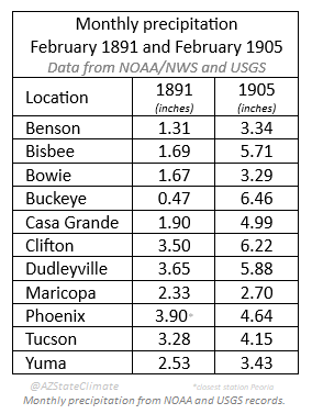
Spring flooding events have been devastating to Arizona. The largest flood ever measured on the Salt River near Phoenix happened February 18-26, 1891. However, February 1905 actually measured more precipitation than February 1891!
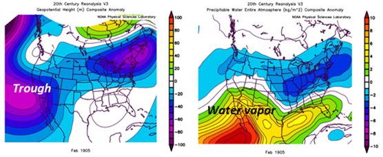
The meteorological setup for February 1905 was quite different from February 1891. The main structure in 1905 consisted of a very persistent trough of low pressure in the Pacific Ocean centered near the Baja Peninsula. The winds moving around the system brought subtropical moisture into Arizona, streaming excessive precipitation across the state. The atmospheric setup in February 1891 came from a very strong trough of low pressure from the Aleutian Low in the Gulf of Alaska.

El Nino-Southern Oscillation (ENSO) events have been evaluated from sea surface temperatures since 1950, but older events prior to 1950 can be calculated with the extended Multivariate ENSO Index (MEI). According to the extended MEI, 1905 was an El Nino year; 1891 was a La Nina year (1).
Temperatures were warmer in January 1905, melting a lot of the existing snowpack. The first part of February 1905 turned colder, bringing snow to Maricopa, Pima, and Pinal counties. February was cloudy most of the month as three storm systems dropped record-level precipitation across Arizona. There were a total of 11 rainy days and actually 2-3 thunderstorm days in February, demonstrating strong dynamics in the atmosphere (2). The wet February of 1905 caused three flooding events along the Verde, Salt, and Gila rivers, however, none were as large as the Great Flood of February 1891.

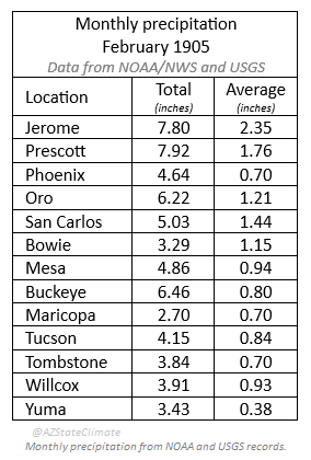
Using modern county boundaries and records back to 1895, every county except Mohave experienced its wettest February on record in 1905 (Greenlee county was established in 1909, and La Paz county was established in 1983). Statewide, this was also the wettest February for the state going back to 1895, with a statewide total of 4.44 inches, more than three times the normal amount of statewide precipitation in February (5).
The vast majority of Arizona’s long-term weather records have been verified back to 1895 (the period of record, or POR) with a a handful of weather station records extending back to the 1870s. Comparing some stations that had records going back to 1891, February 1905 still measured more precipitation across the state than was measured in February 1891, making February 1905 the wettest February on record.
Every county except Mohave had its wettest February in 1905.
Sources
1. NOAA Physical Science Laboratory. Extended Multivariate ENSO Index. https://psl.noaa.gov/enso/mei.ext/
2. Report for February, 1905. W. L. Moore, U.S. Department of Agriculture, Climate and Crop Service of the Weather Bureau, Arizona Section. March, 1905.
3. Destructive floods in the United States in 1905. E. C. Murphy and others, U. S. Department of the Interior, United States Geological Survey. 1906.
4. Summaries of Climatological Data by Sections. C.F. Marvin, Chief of Weather Bureau. U.S. Department of Agriculture Weather Bureau. Rocky Mountain States. 1926.
5. NOAA National Centers for Environmental Information. Climate at a Glance. https://www.ncei.noaa.gov/